
Types of Land Surveys and Which One You Need
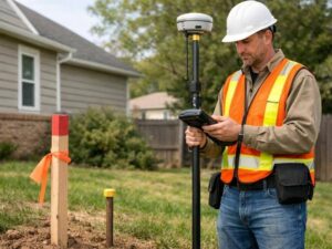 Most people never think about land surveying until something comes up. A neighbor builds a fence too close to your yard. A lender asks for a survey before closing. A contractor needs paperwork before breaking ground. Whatever the reason, land surveying is not a one-size-fits-all service. There are different types of land surveys, and each one is built to do a specific job.
Picking the wrong type wastes money and delays your project. Knowing the difference before you call anyone will save you both.
Boundary Survey
A boundary survey finds and confirms the legal edges of a property. A licensed land surveyor checks old records, deeds, and maps, then goes out to the property and marks the corners on the ground.
This is the most common survey for homeowners. People get one when they are buying or selling land, settling a dispute with a neighbor, dividing a lot, or planning to build something near a property line.
When the survey is done, you get a certified map. It shows exactly where your property begins and ends, along with any easements or encroachments the surveyor found.
Topographic Survey
A topographic survey maps what the land actually looks like. It measures elevations, slopes, drainage patterns, trees, and any existing structures on the property. The end result is a contour map that shows the shape of the land from multiple angles.
Architects, engineers, and contractors use these before designing a building or grading a site. Homeowners planning a major landscaping project or an addition on uneven ground may need one before getting a permit.
One thing to know: a topographic survey does not confirm ownership or property lines. It describes the physical condition of the land, not who owns it.
ALTA Land Survey
An ALTA land survey follows a strict national standard set by the American Land Title Association and the National Society of Professional Surveyors. It is the most detailed survey available. It combines boundary, topographic, and title information all into one certified document.
Lenders and title companies require ALTA surveys for most commercial real estate deals. The survey covers property lines, easements, encroachments, utility locations, and anything else that could affect how the property is used or owned. Because it follows a single national standard, every ALTA survey looks the same no matter who does it or where the property is.
Most homeowners will never need one. ALTA surveys are made for complex transactions where a high level of detail and legal protection is required.
As-Built Survey
An as-built survey documents what was actually built on a property after construction is finished. It measures the real location of the structure, driveway, utilities, and other improvements, then checks them against the approved plans.
Most cities and counties require an as-built survey before issuing a certificate of occupancy for new construction. Lenders with construction loans also typically require one before releasing the final payment.
If something was built even slightly out of position from the original plans, an as-built survey catches it before the project officially closes.
Mortgage Survey
A mortgage survey is a basic survey used during home sales. It shows where the structures on a property sit in relation to the boundary lines. It is mainly used to confirm there are no obvious problems that would affect title insurance.
It is less detailed than a boundary survey and is not meant to resolve disputes or stake out corners. Lenders and title companies often order it as a routine step before closing.
If you want a legally certified boundary determination, a full boundary survey is what you need. A mortgage survey is not a substitute for that.
Which Type Fits Your Situation
Situation | Survey Type |
Buying or selling a home | Boundary survey or mortgage survey |
Building a fence near a property line | Boundary survey |
Planning new construction | Topographic survey |
Applying for a building permit | Topographic survey |
Commercial real estate closing | ALTA land survey |
Getting a certificate of occupancy | As-built survey |
Neighbor boundary dispute | Boundary survey |
Finding or verifying property corners | Boundary survey |
Subdivision or land development planning | Boundary survey and topographic survey |
Frequently Asked Questions
How do I know which survey to order?
Think about what the survey needs to accomplish. If you need to confirm your property lines, get a boundary survey. If you are planning construction, you likely need a topographic survey first. For commercial deals, your lender or title company will tell you if an ALTA survey is required. A licensed land surveyor can also review your situation and point you in the right direction before any work starts.
Can I use an old survey instead of ordering a new one?
Sometimes, but it depends on the age and purpose of the existing survey. If structures have been added, lines have been disputed, or nearby properties have changed, an older survey may not reflect current conditions. Most lenders and title companies have specific requirements for how recent a survey must be. Always confirm before assuming an old one will work.
Does a boundary survey show easements?
Yes. A boundary survey identifies and locates easements recorded in the title history of the property. If a utility company has a recorded easement running across your land, the survey will show where it sits. Easements that were never officially recorded may not appear unless specifically researched.
Does a land survey have to be done by a licensed professional?
Yes, in every state. Only a licensed land surveyor can legally perform and certify a land survey in the United States. In Nevada, surveyors are licensed through the Nevada State Board of Professional Engineers and Land Surveyors. A survey done by anyone without that license has no legal standing and will not be accepted by a lender, title company, or local government office.